Tornadoes, flooding possible in three waves today

Published 4:56 am Wednesday, March 17, 2021
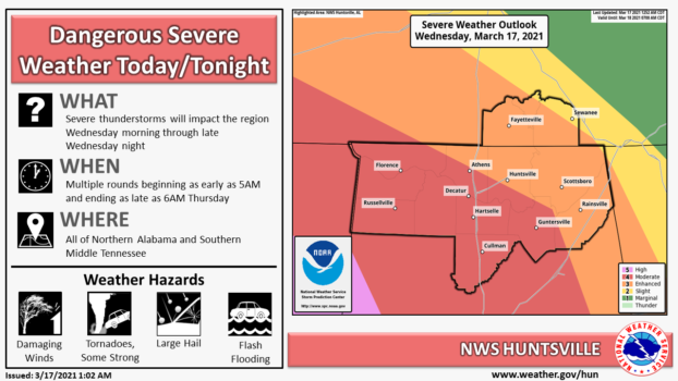
MADISON – With a strong possibility of tornadoes forming in the Tennessee Valley today, emergency management officials are warning residents to be prepared for power outages, damaging winds and possible flooding.
Madison City Schools are closed this week for spring break, but other surrounding school districts have decided to teach virtually today or close.
On Tuesday afternoon, Gov. Kay Ivey issued a state of emergency for all 67 counties. Local EMA workers are urging residents to stay weather aware, have a plan, have supplies and decide on a place to go before the storms strike.
Jessica Chace, meteorologist with the National Weather Service in Huntsville, said the first of three waves of threatening weather will arrive in the area about 5 a.m. She said the second is forecast to pass through about 11 a.m. and the third, expected to be the most severe, will arrive about 7 p.m. The first two waves will carry warm air from the Gulf, she said.
“Between 5 a.m. and 9 a.m. around the Tennessee River, the area could see elevated thunderstorms with the main risk being quarter-inch to 1-inch large hail,” she said. “We could see 60 mph winds and an isolated tornado.”
The second round of activity will arrive from 11 a.m. to 6 p.m. with “dangerous winds and a greater threat of tornadoes,” Chace said.
She said the third round will move in from the west between 7 p.m. today and 2 a.m. Thursday with damaging winds, large hail and “the highest threat of strong and long-lived tornadoes is possible.”
“We’ll see a heightened risk for flash flooding, too,” Chace said. “These storms have the potential to be one of the most severe events we’ve had in a couple of years. … Going into the overnight, don’t put your cellphones in the ‘do not disturb’ mode, so you won’t miss any weather alerts.”
Ivey urged state residents to make plans for the potential severe weather conditions.
“Please make preparations now in the event your area is impacted in some way,” she said. “I will continue keeping a close eye on the system and encourage every Alabamian to do the same.”
Chace said once the storms move through early Thursday, the temperatures will fall, but a pleasant weekend is expected.
“Thursday, temperatures will be cooler but it won’t be as muggy as the air will be drier,” she said.
She said Thursday’s highs will be in the 60s and Friday’s high will dip into the 50s.
“A beautiful weekend is forecast with Saturday’s and Sunday’s temperatures to be in the 60s under clear skies,” she said.

